To Lhasa to Leh!

Tuesday, November 29, 2005

Summary/HIghlights

  1. 3000 kms
  2. 20 passes (all above 4000 mts)
  3. Accross world's top 5 highest motorable passes!
  4. 1 month
  5. Past Kailash Mansarovar
  6. Will view - Mt Everest along the way
  7. Longest Himalayan Motorbike journey (so far)

the route in detail.

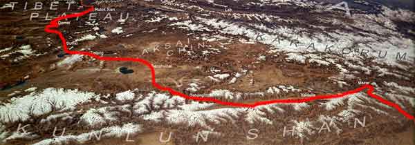
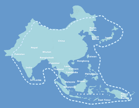
Read backwards (as in we come from lhasa to Rutok Xian)

Rutok xian
4160 ASL occasional checkpoint. PSB!, international calls, bank of china, market, shops, turn left after the city for Ali

pass 4800 flat uphill until 1 km before top.

ALI 4370 MTS capital of ali prefecture, everything, hot shower, backpacker girls.$US cash to yuan - not travellers checks or VISA

pass 4735 by GPS. Turn left after Ali for shortcut. Don't follow telephone poles for 41 km longer nightmare road!

namru - old village, turn off to thölling
namru - new village, noodles, drinks, dormitory

4632 ASL by GPS. More like 7 km to pass.
basic food and beverage - -army base - basic food and beverage, shop, dormitory
basic food and beverage - -1

pass 4720 -

pass 4820 -

misar
- important town. restaurants and shops. turn off to tirthapuri hot springs. Checkpoint at beginning of town.

river - difficult to cross,basic food and beverage - -

pass 4900

turn off darchen - after rivercrossing. Very bad road on downhill section. restaurants, shops, clothes, big rivercrossing just before town, small ones after town

turn off to purang -- shops, restaurant, gazoline station.

horqu - shops, restaurant, stuck up with supplies here. Turn left into the vally after town, not around the lake.

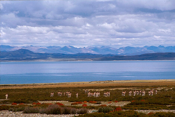
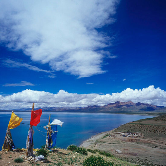
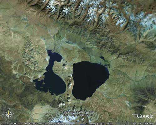
lake - Catch fish by hand. Very sandy road

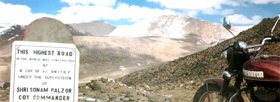
mayun pass 5250 MTS ASL

tents and house - basic food and beverage

pass 4800

turn off to new zhongba - Big shops, restaurants, road-repair-station, internat. calls. 7 km.
1967 1703 22 first marker after misar - l----> N. Z. Turn left for town just after entering the big

old zhongba - basic food and beverage, shop, road-repair-station-road-repair-station - -

pass 5000

road-repair-station - -

pass 4930 MST ASL

saga 4510
important town. restaurants and shops, etc. turn off to zhangmu. end of highway 219

ferry crossing - 2,5 Y per vehicle or free

pass 4830


pass 4860 Very bad road!

pass 4946

nature preserve center - basic food and beverage, sleep when open, checkpoint?
roadsplit - Turn left up into the pass just after the bridge

pass 5011

4 reaching highway 318 4600 Entering between a dobbelt pass

pass 5150

5 road-repair-station 4900 end of descending, begin of ascending. basic food and beverage. sleep. 4882 by GPS

pass 5120

village 4580 road-repair-station road-repair-station - -
2339 5326 8 road-repair-station - army base

nyalam 3810 important town, checkpoint before entering town
2389 5375 31 checkpoint - -

zhangmu 2800 important town, chinese border.

We Join here from the road from Lhasa...

kodari - nepalese border town

More images (sattelite) of the road from Kathamndu to Rutog Xian (where we turn off for India). Rutog is a comparitively large town with mney exchange, bank of china. ISD facility and even internet! its at about 4200 mts ASL. The graph shows our ascent descen route!

NEED PULL!!

Anyone knwo anyone in the chinese embassy - Delhi - or anyone knwo any chinese politician?

Monday, November 28, 2005

where we see it...


again dont count me 100% on this, but i am very close to the truth! We can see Everest from one point on the highway! Its going to be one hell of a feeling to see the highest point ofland on this whole planet~

EVEREST!!

Still Working on it, but i think we shall see everest from one angle, whilst ont he friendship highway! Lets hope for a clear sky!............

Friendship Highway


The Friend Ship highway lies between kathmandu(Nepal) and lhasa(Tibet,China). Though it is termed as a "highway", its more of a bit of ruble layed out and covered by snow! It crosses upto 4-5 passes above 5000 mts and has snow on it for 365 days a year. in summer the streams cut away part of the highway, making it treachorously dangerous. Nevertheless it cant be more challenging and exciting...


maps!

A very kind soul, has put up a very high resolution map of the journey (satellite photo) and even marked the highway out for us! This is by far the best proof we have of an existing route along the journey. bang through kailash-mansarovar regions....

the reason i am posting so many photos(sattelite) and maps, is to overcome this belief that we are "creating" a road. I insist,we are not, but are simply creating A journey from existing roads!


Images from the road...


Some more images, revealing this beautiful landscape we are about to experience, images are from the Mansarovar, Mt. Kailash region...

Sunday, November 27, 2005


Came accross a nice picture, its on the way from Lhasa to Kathmandu!

P.S what you look like after u ride through 100 kms of crap roads!

Delhi to Beijing Solo!

Came accross this while seatching for some more infp. This person has done the 7500 kms trip to beijing.

    With the closure of traditional trade routes between India and China like the Old Hindustan Tibet road in Himachal Pradesh and the Kalingpong to Lhasa route, the capitals of the two country's are now connected only with one all weather metalled roadway, via Nepal. Starting from Delhi, one has to first ride through the State of Uttar Pradesh and then cross over into Nepal and proceed towards Kathmandu, either directly or by slightly longer route, through Nepalganj and Pokhra.
    The Sino-Nepal Highway starts from here, reaching up to Lhasa covering a distance of over 2500 km across the Himalayas and the Friendship Bridge into the Tibetan Plateau. Beyond Lhasa there are two alternative ways for proceeding towards Beijing. One is through Naqu and Golmund via the Quinghai-Tibet Highway in the north before turning north-east (the route of the 1997 Peking to Paris Rally), the other is via the Sichuan-Tibet Highway (No. 318 National Trunk Highway) to Chengdu in the east and then turn northwards towards Xian and to Beijing.
    The preferred route would of course be the eastern one, i.e., via Chengdu, with a detour to Dali and Kunming via the Yunnan-Tibet Highway (a section of No.214 National Trunk Highway) and then onwards to China's ancient capital Xian, the nearby sacred Huashan mountains and culminating in historic Beijing. All places of historical and cultural importance, each playing a significant role in shaping the destiny and traditions of their country.

Who is he? here goes...
    Never having formally studied literature or journalism, twenty-nine year old Ravi J.Deka has nonetheless spent the last four years in the world of freelance writing, penning a contrasting array of stories stretching from travelogs and heritage studies to auto journalism. Till date his articles have featured in national newspapers like Business Standard and Sunday Observer and regional ones like The Assam Tribune and The Northeast Times. Overseas his renderings have appeared in prominent publications like Whole Life Times and Travelocity. Formerly a monthly columnist of the widely read "Indian Auto" magazine, he has also written on motorcycling related topics for widely popular Internet portals like www.streetbike.com and www.gonomad.com.
Why no pictures? - thats what even I asked. Please sir may we see some?


Bikes used by the guys who conduct bike trips into the himalays (ladakh, nepal and tibet). Mind you they have a truck full of spares and other stuff coming close behind.


The "Indian sheperds"conduct bike tours tot he everest base camp, and around nepal - but no one has ever ventured on such a long, and sceneic journey - so we have a chance topull something out of the bag here.(http://www.asiasafari.com)

"The ride is a Barometer understanding challenge of high altitudes. Here oxygen is as sparse as population due to lack of tree line. It is an out of the World experience of riding classic technology Royal Enfield – 500 CC, surely an acid test of the technology & respect for Human endurance. This motorcycle safari shall surely leave us a changed biker - to have more confidence, compassion, love & respect for each other and mankind."
(http://www.asiasafari.com)

Route 1: Kathmandu - Lhasa - Khamba la Base Camp - Khamba La (4970 M) - Nakartse - Yumdrok - Karo La (5045 M) - Gobsi - Simi La - Gyantse - Panam Dzong - Shigatse - Lhatze - Tingri - Everest Base Camp - Tingri – Nyalam - Zanghmu - Kodari - Nagarkotte - Bhaktapur - Chitwan - Kathmandu

Reliable Road Map


I found this brilliant map of the roads in tibet. Looks like we are going on highways - though i doubt they will be 2 lane expressways! But a highway should be accessible to public (with permission). so lets see..

anyway if anyone wants a copy of this map (high rez) mail me!

A rought idea of the itenarary from Kathmandu to Lhasa (via Shigatse)....
Day 1 Flight to Nepal.
Day 2 Arrival in Nepal in the morning. Transfer to Dulikhel. We get to know each other and the motorcycles and enjoy the first sights of the Himalayan range.
Day 3 From Dulikhel along green Hills and terraces towards Tibet. From 400 m up to 3200 m at Nyalam.
Day 4 A first glimpse of the Himalayan panorama in Tibet. Xsisangpangma and Cho Oyo are (hopefully) visible on our way to Shegar.
Day 5 Further on to Shigatse, Tibets second largest city.
Day 6 A long trip to Lhasa.

A change in route...


the new route after an initial discussion, we fly from bangalore to Nepal - kathmandu, then acclamatize before doing the Kathmandu, lhasa journey (highway) and then start a new route to Leh....

Thursday, November 24, 2005


The highest road ever built! Just next o Pangong and China, we should be crossing this at some time. Its called Marsimik La (La meaning pass) and is about 500 ft higher then Khardungla (which is officially known as the highest motorable road in india! At khardungla there is always snow so i can only imagine what Masirmik would be like!

So the top 5 are all in ladakh

1 Masirmik la (we cover this) (some 6300 mts ASL)
2 Khardungla (some 600 mts ASL)
T3 anglang La (5800 mts ASL)
4 Chang La (We cover this) (5700 Mts ASL)
5 Lachung La (5500 mts ASL)

image courtesy 60kmph


last time i hit ladakh - it was cheap russel market army store gear! I really doubt that tp fit in to this idea!! SO again, i guess this means "wear" is an investment? www.thenorthface.com


I dont think any indian ISI marked helmet is going to make it through! so how bout Arai?

just a thought, the last time i took a studs helmet, the wiser came off before i did the first 100 ksm from Jispa to Leh!


Well if we could splurge a bit, and if people felt home sick this is an option: ACeS - (Asian Cellular Satellite) Service Provider have coverage over the area we are going to, we can use the The

"Ericsson R190 pocket phone weighs just 210 grams, so for the first time this phone can be used for GSM and satellite calls without being too bulky. The R190 operates as a GSM or satellite phone or with GSM or satellite preferred; the phone will automatically switch to the
alternative network if the preferred mode is not found."

BTW that was $535.70!!!

and its got built in radio (two way) to communicate as well!


  • Whopping 5 watts of transmit power (GMRS) means you can now call for help from 14 miles away (transmit power limited to 2 watts in Canada with a range up to 8 miles)
  • Automatic route generation, off-route recalculation, turn-by-turn directions with alert tones, and icon-driven menus for finding points of interest.
  • Mini USB and 56 megabytes of internal memory for rapid download and lots of map storage of Garmin’s entire line of outdoor cartography
  • Rechargeable lithium-ion battery for up to 16 hours of outdoor use
  • Barometric altimeter provides extremely accurate elevation for hikers and climbers
  • Electronic compass so you can get a heading when standing still
  • NOAA weather capability to keep you informed of changes in weather


Now thats a good place to be photographed! The bikes - thats the key. Will we get a bike that makes it through? I say a souped up Royal Enfield maybe the thunderbird for single riders and 500cc for riders with pillion. By souped up i mean -

upgraded (gas) suspension, disc brakes (front), heated hand grips (?), shock proof boxes and carrier for backpacks, provision to add a GPS on the dash board (next to the speedometers), Fog lights, upgrade 12V DC battery, Warmers (to keep the engines from getting cold at night), Tubeless tyres (boy what a difference this could make), strong clutch and brake cables, 45 litre fuel tank (or 22 liter but 45 is better).......

thats the bike part (with more to come) what else will we need? here goes..

GPS
GIS maps with elevation, route and climate details (?)
Solid gloves (to keep ur fringers from breaking off)
Digital Cameras with zoom
Laptop - to download the images

more as i figure them out.....


that was Ewan and Charlie - wonder what we can get?

Wednesday, November 23, 2005


one of the gazzllion lakes that tibet has!


The Quinghai - Tibet railway! A tourist Marvel, a political disaster!

net connection really slow so cant post any more images today :(

A nice travelogue by a vistor to tibet
read the full story @ here

Lhasa literally meaning “Holy-Land”, is the heart and soul of Tibet, it has history of more than 1,300 years. Lhasa has remained Tibet's capital since 1642, and most of the city's historical sights date from the second stage of the city's development since the fifth Dalai Lama. Buddhism is a center form of Tibetan daily lifestyle. Monasteries and various temples are clustered in the city.

Lady's temple

Among those shrines, a ladies temple is quite unique and interesting. It is located within the Lhasa city in a residential area. Driving from downtown area will only take about 30 minutes. There are more than 150 lady monks living in the temple with a center garden and few souvenir shops. Residents in this temple will not participate in any activities outside the compound. They read Buddhist script, study Lamaism and helping each other with daily works. Tourists are allowed to enter, but limited to the worship area only.

Lhasa city has an elevation of 3,658 m, the city also known as Sunlight City, is the highest city in the world.

In Tibetan language, Lhasa means "The land of the Gods". Lhasa enjoys delightful weather, throughout all the seasons. The average temperature is 7.4 census. Most of the yearly rainfall hits in July, August and September.

From Lhasa to Samye Temple, one of the very significant Tibetan Buhdast monasteries takes about 4 hours by car. Then to shorten the distance, we got to the closest dock to cross the Yaluzampu river by boat. In a normal day, the boat operator will wait for a full load of passengers before departure. It only costs 15 RMB per person. However, if you are in a hurry, an option of paying 190RMB could satisfy the boat owner starts the engine immediately.

From the bank, the yaluzampu rive looks calm and narrow. I thought it would only take us 15 minutes to cross it. However, in a low water season, we had to take extra distance going up and down the river to avoid stock in the shallow riverbed. This way we spent more than an hour on the journey instead of 15 minutes. Everyone on the boat seemed to enjoy the trip and the stunning scenery, but the operator was so intense on his work. He had to fully concentrate on the invisible river route to make sure the boat will not get stocked. When we approached the parking dock, it was such a release showed on his face that everyone was happy of a safe landing. Nevertheless the way to reach Samye temple is not finish yet.

Samye was Tibet's very first monastery and has a history that spans over 1,200 years. It is designed to represent the Buddhist universe and many of the buildings in the courtyard are cosmological symbols. The central building of Samye, its foremost feature, comprises a mixture of architectural styles: the ground and first floors were originally Tibetan in style, the second floor was Chinese and the third floor was Indian.

Might be useful :)

With unique culture and religion, Tibetans have different ways of behavior in many aspects. There is an old Chinese saying: "Sing the local songs when you get to a local place." So please keep in mind the following tips:


1. Remember not to step on threshold when entering the tent or house.

2. Calling somebody in name please add "la" behind the name to express respects.

3. If you are asked to sit down, please cross your legs, do not stretch your legs forward and face your sole to others.

4. You should accept the gift with both hands. While presenting the gift you should bend your body forward and hold the gift higher than your head with both hands. While offering tea, wine or cigarette, you should offer them by both hands and any fingers do not tough inside of the bowl.

5. Do not touch, walk over or sit on any religious texts, objects or prayer flags in monasteries.

6. When the host presents you a cup of wine, you should dip your ring finger in the wine and flick the wine into the sky, in the air and to the ground respectively to express your respects to the heaven, the earth and the ancestors before sipping the wine. The host will fill the cup, and you take a sip of the wine again. After the host fills your cup again, you have to bottom it up.

7. Tibetan people do not eat horse, dog and donkey meat and also do not eat fish in some areas, so please respect their diet habits.

8. It is not polite to clap your palms and spit behind the Tibetan people.

9. Tibetan people stretch out their tongue to say hello to you. Also it is a courtesy to put their hands palm in front of breast.

10. Do not smoke in monasteries. Also it is banned to touch the statue of Buddha and religious articles and take pictures of them. In addition, all should walk clockwise (not in the Bon temples).

11. Seeing any dagobas, monasteries or Mani piles, please go around them clockwise (not of the Bon), do not cross them.

12. Eagles are the sacred birds in the eyes of the Tibetan people. You should not drive them away or injure them. On the outskirts, you could not drive or disturb the sheep or cows with red, green or yellow cloth strips on


Photographs taken from my last trip to Ladakh
1. ont get fooled by the quality of the road, this is indeed a rarity!
2. Pangong Tso at Sunrise - Something esle!
3. Leh from the Shanti StupaD

Tuesday, November 22, 2005


The tilt facility on google earth is fabulous! gives u a clearer idea of this journey - and thier ups and downs (pardon the pun!) - BTW posting google earth images is legal right?


Mt Kalish region as seen from Google earth, after a more detailed study i think we shall be missing Mt.Kalish by about 50 -60 kms (it being to our west) as it lies too close to the indian border. But we will still be able to see it (i really hope so), with no religious connections, I still want to see it! :)

Long 80 35N ,Lat 80 30N


If


Following the original route, then we should be passing Mt.Kailash somewhere along the area before Rutog. Somewhere near gartok.Journeys to Kailash are conducted on Toyota Land Cruisers, and follow no road as teh whole are is barren and flat.

We need some good GPS instruments!


Pangong Tso the lake - view from the chinese border.....other side of the lake, and its INDIA!!
Photo from Corax Adventures and Expeditions

Monday, November 21, 2005


just to get a clearer picture of what the plan is, here is a route map created using maps avaliable online and google earth. all the tracks are on existing roads, and i dont suggest in any map a road created by us!


Pangong looks a bit flat from the sattelite imagery - so i thought a few photos would give you the "real picture"! Its heavenly! Its Divine - Its something else! Its liquuid Crystal!

Status

Tuesday, November 22, 2005

9:33:52 AM

Having sent a letter to the Chinese embassy and the defense ministry it is a question and matter of time, before any further progress. It is hard to think further until this conditional permission has been given by the respective countries. Being the first trip through this area, I think the chances are slim, but with India China relations at a high, maybe things could change here!

So long,
Narayan

Friday, November 18, 2005

To,
His Excellency,
The Ambassador of China
THE EMBASSY OF PEOPLE’S REPUBLIC OF CHINA IN INDIA
50-D, Shantipath, Chanakyapuri,
New Delhi-110021 India

Thursday, November 17, 2005

Sub: PERMISSION QUERY FOR ENTRY INTO CHINESE TIBET

Dear Sir,

We are a group of enthusiastic and experienced Bikers, who wish to conduct a motorcycle journey from the region of Tibet, originating at Lhasa, then riding through Tibet, and wish to enter India via Ladakh, and conclude at Leh, India. Please find in the sheets attached a Map we have traced using existing road maps available to plot a possible route.

We wish to do this for the following reasons

• Experience the extravagant and rare scenic beauty presented by the land
• Promote peace and well being between the two countries (India and China)
• Execute a never before motorcycle journey between two historic locations
• Raise money for charity to a notable and international aid agency.

I wish to enquire about the permission...........................................

Wednesday, November 16, 2005

Our Destination


Leh as seen for Earth SAT - courtesy google earth! - u can c the runway on the left hand side bottom (in box).

Lhasa, Tibet/China - courtesy google earth. We head east from Lhasa and then turn north about 100 kms later...


The area with trouble! The part between Rutog and Lukung, where we have to pass throught about 100 kms of No Mans Land! Have to get permission from the chinese to exit the country, and permission from the Indians to enter!so this is the tricky part!

Am still wondering, how hard its going to be to persuade the chinese to allow me to bring in bikes from India and ride it around!Was thinking of trying to get a chinese manafacturer but then it woudl probably me a use and throw bike! which means we woudl need about 20 (for the 20 legs of the journey!!) :)

a revised route - really not too sure which one to take!!

Tuesday, November 15, 2005


Images from the road - Lhasa to Leh. I'm dead serious about this mind you......

Monday, November 07, 2005

DREAM DREAM COME TRUE PLEASE!


“I shall be telling this with a sigh somewhere ages and ages hence: Two roads diverged in a wood, and I - I took the one less traveled by, and that has made all the difference.”- Robert Frost

Wednesday, November 02, 2005

sometime soon!


one
of my would be diestinations, time and money permitted....


d